1849 Henness Pass Trail
Contributed by Steve F. Russell
The Henness Pass Trail/Road connected Virginia City, Nevada (and Carson City) with Marysville, California. West of Hoke Valley, California in 1849, it was just a trail. East of Hoke Valley, the 1852 road route is intermingled with some of the earlier routes, but its route west of Reno to Carson City was distinct. Its highest elevation, at Henness Pass, is 6920 feet. The total length of the wagon road from Marysville to Virginia City, is 168.3 topographic miles.
Interactive Center Line (Verdi to Camptonville)
Static Map
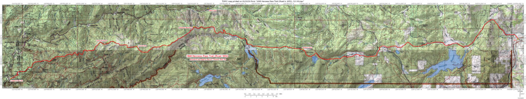
The Henness Pass Road
Credit for pioneering the route is given to Patrick Henness in about 1849 or 1850. Prior to the completion of the transcontinental railroad in May 1869, Henness Pass became one of the two or three most heavily traveled routes over the Sierra. David Wood and Thomas Freeman traveled the Henness Pass Road in October 1859 to see if a practical route from Marysville to Gold Hill was available.
This route, across the Bridgeport Covered Bridge, reduced the original route to the Virginia City, Nevada silver strike through Carson City by 15 miles. During its heyday, traffic became so heavy that freight wagons were required to run during the day and stagecoaches during the night. In the 1860s it’s thought that up to 100 wagons per day crossed the bridge. An article in the Grass Valley Union of July 26, 2008, stated “Commencing in 1860 and continuing for some nine years, the Henness Pass Road was one of the busiest Sierra crossings. This route was favored by teamsters and stage drivers over the Placerville route because of its lower elevation and easier grades.”
This description of the Henness Pass Route was printed October 22, 1859 in the North San Juan Hydraulic Press:
On Monday, the 10th inst., a party composed of Thomas Freeman and David Wood, both experienced road-builders, with other persons, of whom the writer of this was one, started from North San Juan on a journey to Carson City, Utah, and the new silver mines of the Eastern slope, by way of Henness Pass, with a view to ascertaining the most direct practicable route for a road connecting Marysville, North San Juan, and other towns in Yuba, Nevada, and Sierra Counties with the important regions on the Eastern borders of our State, which is now being rapidly peopled. We propose to give as succinctly as possible, the results of this expedition, with direct reference to its special object, leaving whatever else of interest was learned for other occasions. The party pursued what is known as the Emigrant Road along the river dividing the North and Middle Yubas, up the latter stream to the summit, through the Henness Pass into Truckee lake Valley, down the Little Truckee with its succession of linked grassy vales, to Dog Valley Hill, over this hill to the main Truckee, southward through Truckee Meadows, Steamboat, Smith’s and Washoe Valleys, to Carson City in Eagle Valley, and thence northward to the Virginia City or Washoe Diggings. This made a total distance from North San Juan of 107 miles, and from Marysville of 143 miles. In returning, the party avoided the circuitous route in going from Steamboat Valley to the diggings, and crossed the range of mountains lying between them and said valley by a direct route which follows the course of a canyon, thus saving 15 miles, — and reducing the distance from Marysville to Virginia City to 130 miles—making it shorter than any other route. Through this canyon parties are now engaged in building a road.1Found at the Bancroft Library, Berkeley, California, by Verna Wood Dunshee.
California-Nevada Chapter of the Oregon California Trails Association has written a short pictorial essay entitled “Henness Pass Road”.
Notes
- 1Found at the Bancroft Library, Berkeley, California, by Verna Wood Dunshee.