John Mullan’s 1863 Map (Annotated)
Contributed by Steve F. Russell
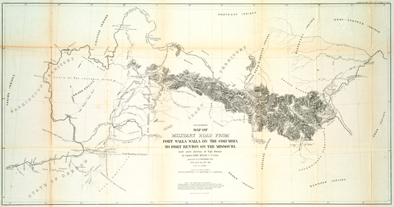
John Mullan’s 1863 Map entitled “Map of Military Road from Fort Walla Walla on the Columbia to Fort Benton on the Missouri“ is a landmark 19th-century map created under the direction of U.S. Army Lieutenant (later Captain) John Mullan. Published around 1863 as part of Mullan’s official report to the U.S. Senate, the map documented the survey and construction of the Mullan Road—the first engineered wagon road crossing the Rocky Mountains.
This map has been annotated by trail researcher Steve R. Russell to enable the viewer to quickly find key landmarks.
View Map
Overview and Purpose
- The Route: The map charts a 624-mile route connecting the navigable headwaters of the Columbia River basin at Fort Walla Walla (Washington Territory) to the Missouri River at Fort Benton (Montana Territory).
- Strategic Intent: Commissioned by the War Department following Isaac Stevens’s northern railroad surveys, the road was meant to facilitate rapid military troop and supply movements between interior frontier garrisons.
- Cartographic Team: Prepared by draftsman Edward Freyhold from extensive field notes collected between 1858 and 1863 by Mullan and his topographers, including Theodore Kolecki, W.W. de Lacy, and artist/interpreter Gustavus Sohon.
Features
- Topography & Relief: Mountain ranges across present-day Washington, Idaho, and Montana are depicted in detail using traditional hachure lines.
- Historical Land Use & Settlements: It marks military forts, expedition campsites, river ferries, mountain passes, and early pioneer settlements—such as Antoine Plante’s ferry on the Spokane River.
- Indigenous & Pioneer Trails: Native American trails and approximate territories of regional tribes are designated alongside conflict and battle sites.
- Resource Notes: Highlights sources of timber, natural springs, grazing prairies, and emerging gold strikes.
Historical Impact
While built for military transport, the completion of the road in 1862 coincided with major gold strikes in Idaho and Montana. Thousands of miners, prospectors, and homesteaders used the mapped route to reach the interior West. Decades later, civil engineers used Mullan’s surveys to help lay the path for the Northern Pacific Railroad through the Northern Rockies.1Report generated by Google Gemini August 2026; map annotated by Steve F. Russell.
Notes
- 1Report generated by Google Gemini August 2026; map annotated by Steve F. Russell. ↩︎