The Carroll Trail 1875
Contributed by Steve F. Russell
The Carroll Trail was a wagon road in Montana used to ship freight from Carroll Landing on the Missouri River to Helena, Montana and the Montana gold fields.
Prehistory of the Carroll Trail
In the late 1860s and early 1870s the U.S. Army had a great desire to develop shipping routes to supply the forts of Montana Territory. Several reconnaissances were conducted for this purpose but the one commanded by E. W. Clift in the spring of 1869 was the most significant for the Carroll Trail because it demonstrated the feasibility of wagon roads from the Missouri River near the mouth of the Musselshell River to Helena and the Gallatin Valley. Clift was responsible for the exploration of a wagon road route from Fort Ellis, near Bozeman, to the mouth of the Musselshell River. The Missouri river boat landing at the terminus of this route was first known as Musselshell City and later as Fort Musselshell. The portion of Capt. Clift’s route between Armell’s Creek and Martinsdale would become apart of the Carroll Trail. The history of the Carroll Trail began when Lt. Gustavus Cheyney Doane, from Fort Ellis, established a steamboat landing in May, 1874 as the Missouri River terminus of the Fort Ellis-Carroll Wagon Road. The settlement that grew around this landing was to be know as the “town” of Carroll.
Why Was There a Carroll Trail?
The Carroll Trail was established by the merchants of Helena to serve as a freight wagon route between Helena and a suitable steamboat landing on the Missouri River. They wanted a third alternative to the two principal routes already in existence — the Helena-Fort Benton Wagon Road and the wagon road that went past Virginia City and ended at Corinne, Utah. Both existing routes had problems of high cost and poor reliability. The wagon road to Corinne connected with the Union Pacific Railroad but was at a distance of over 450 miles which caused a considerable freight expense and delays during bad weather. The wagon road to Fort Benton was a toll road and expensive. Also, because Fort Benton was the upper limit of river navigation, the shipping season was frequently shortened by low water.
As a consequence of these problems, and to provide the two existing routes with more competition, the Carroll Trail was developed. Freight shipping with minimum cost and maximum reliability was very important to the merchants of Helena who were a main source of supplies for the gold fields of central Montana.
Origin of the Name
The Carroll Trail was also know as the Helena-Carroll Wagon Road and, more simply, as the Helena Road. It was named for Matthew Carroll, one of the owners of the Diamond R freight company. The Diamond R was a major freight hauler in territorial Montana.
Where Was Carroll Landing?
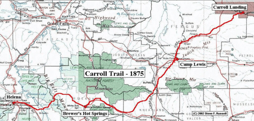
Carroll, Montana Territory, was located on the south side of the Missouri River approximately 166.5 river-miles below Fort Benton and about 38 river-miles above the mouth of the Musselshell River. It was very near the mouth of what is shown as Carroll Coulee on modern topographical maps. This is approximately 18 airline miles north of Valentine and 32 airline miles ENE of Roy. Carroll is now within the Charles M. Russell National Wildlife Range. The location on modern topographic maps is approximately Latitude 47/34/37 and Longitude 108/22/33, or also T21N, R26E and between sections 15 and 16. The river course has changed and has eroded away the original townsite.
Determination of its exact location was a major goal of the author’s research and has required much careful work. Some authors have reported its location as near Cow Island and others have located it at the mouth of the Musselshell. Adding to the difficulty is the fact that cartographers of the late 1800s had little information about the land and creek topography of this area and made large errors in some of the maps prepared during that time.
What was Carroll Like?
Carroll was a rudimentary steamboat landing for Missouri River freight bound for Helena, Camp Baker, and Fort Ellis when Capt. William Ludlow, U.S. Army, was there on July 27, 1875, he described Carroll thusly:
“Carroll is a frontier ‘town’ of perhaps twenty or twenty-five log buildings, on the south bank of the river, six hundred and forty miles above Bismark and one hundred and sixty-five miles below Fort Benton ,the limit of navigation on the Upper Missouri. The town is situated on a timbered plateau 15 or 20 feet above the level of the stream at low water, in the river-valley, which is some 800 to 900 feet in depth, with steep clay slopes covered with pine.”
Where Was the Carroll Trail?
The trail started at Carroll Landing and went West Northwest to just north of Roy. From there it crossed Armell’s Creek and turned South Southwest at Hilger. It crossed Big Spring Creek 2-3 miles below Lewistown and went on a direct line to Judith Gap. From the Gap it went on a direct line to the forks of the Musselshell near Martinsdale. It followed the North Fork to Copperopolis and then crossed the divide to the North Fork of Smith’s River and down it to White Sulphur Springs. From White Sulphur Springs, the trail west closely followed the current public road to Confederate Gulch passing Fort Logan, Watson Post Office, and Diamond City. At the mouth of Confederate Gulch, it went west crossing the Missouri north of Diamond Island, and then continued west to the mouth of Beaver Creek where it proceeded up Beaver Creek and Antelope Creek to just north of where Highway 287 crosses Antelope Creek. From that point it closely follows the highway and/or railroad through East Helena and into Helena.
The description above applies to the route only for the years 1874-75 because there were many changes to the route and settlements of the Carroll Trail over the many years of its usefulness but a description of these must be left to another time.
What Happened to the Carroll Trail?
With the completion of the Northern Pacific railroad in 1883, the Carroll Trail was no longer needed to supply Helena. However, the usefulness of much of the route would continue for many years. In fact, much of the exact route is still in use today.
For example, part of the Carroll Trail served as a main route for freight, mail, and homesteader migration in the area from Confederate Gulch to the Judith Basin until the completion of the Chicago, Milwaukee, St. Paul, and Pacific RR up the Musselshell River about 1908. After this, the travel routes, and many settlement locations, were altered to meet the needs of convenient railroad access. In one sense, we can say the life of the original Carroll Trail was less than ten years but we can also say that many portions of it have served the needs of the area, in various ways, even up to the present day.
Copyright © 2002, Steve F. Russell, All Rights Reserved
Related Documents
Carroll Trail Report
Carroll Trail Report (Abridged)
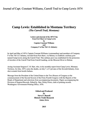
Journal of Capt. Constance Williams