1841–52 Trails to California
Skeleton Maps and Trail Descriptions
Contributed by Steve F. Russell
Early explorers often created field maps, called “skeleton maps,” to illustrate the trails or routes followed and the geographic landmarks that helped define their locations. Following are twenty route segments that make up the trails to California. These trail routes evolved as travel needs, and destinations, changed. Travelers frequently exchanged route information with others so they could improve their travel times and travel safety.
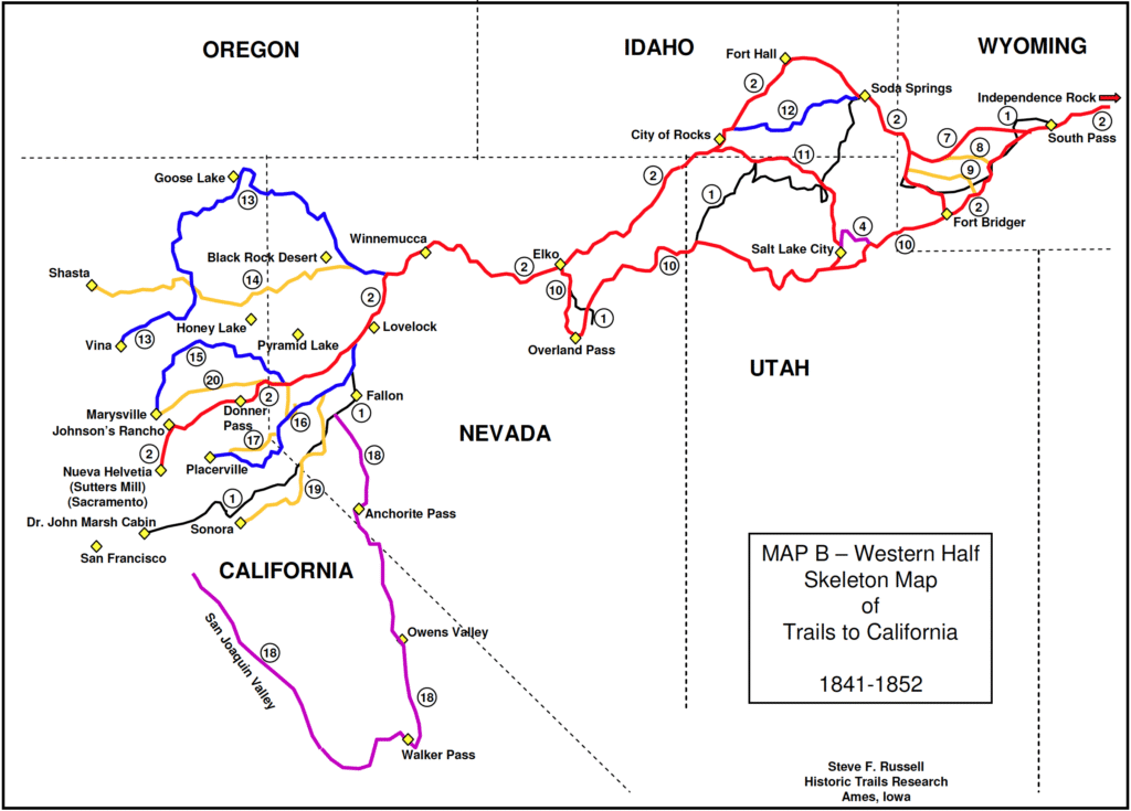
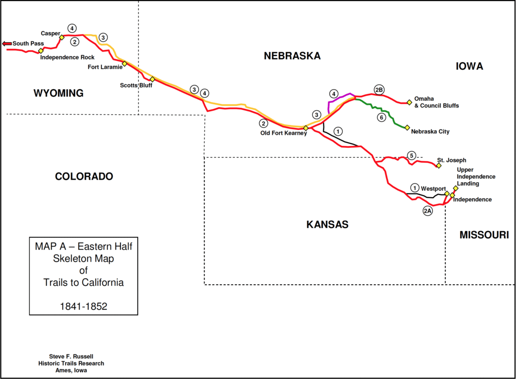
Skeleton Map
1851 California Trails (Symbolic)
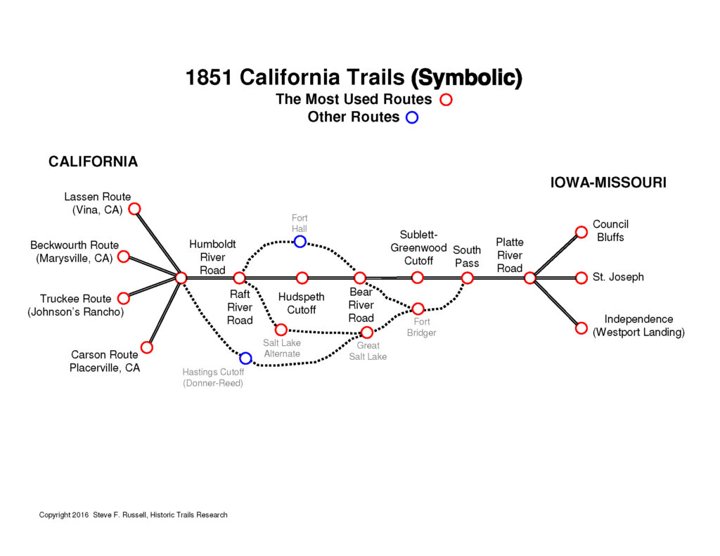
This is an abridged list of most of the important emigrant and “gold” trails/wagon roads to California. Most of the shorter, local routes within California are not included.
California Trail (Bidwell-Bartleson) 1841
As far as we know, the Bidwell-Bartleson Party were the first to attempt to take wagons over the Oregon-California Trail to northern California. They followed the generally established Oregon Trail to west of Soda Springs, Idaho, and then went southwest toward California and arrived at the cabin of Dr. John Marsh, about 30 miles east of Oakland, California. They crossed the Sierra Nevada Mountains south of Ebbetts Pass and north of Senora Pass.
They had to abandon their wagons at Big Springs, Nevada (in Goshute Valley, on the east face of the Pequop Mountains). This was about 470 miles short of the pass they crossed to go into Paradise, California.
Joseph Walker also tried to take wagons to California in 1843, but they failed to cross the Sierra Nevada Mountains. He abandoned the wagons in the Owens Valley of central California.
The first wagons into California were with the Stephens-Townsend-Murphy Party that crossed Donner Pass in 1844 and arrived at Sutter’s Fort. It seems they used the Oregon Trail route to Fort Hall, Idaho and then followed the same general route as Joseph Walker in 1843, along the Raft and Humboldt Rivers to the Truckee River, where they followed the trail over Donner Pass and on to Sutter’s Fort.
Its highest elevation, at Disaster Pass, California, is 7416 feet (a meager 5 feet higher than South Pass!). The length of the trail from Westport Landing, Missouri to Dr. John Marsh Cabin, California, is 2151.5 topographic miles.
[View article and center line map]
Main California Trail Route 1848 (Old Fort Kearney, Nebraska to Sacramento, California)
It is difficult to define a “main” California Trail because there were so many variations to the route, and it changed frequently over time. At the starting points along the Missouri River, emigrants were using St. Joseph, Westport Landing, and Omaha/Council Bluffs. By 1849, they were switching from Westport Landing to Upper Independence Landing. These routes are shown in Red.
Between Old Fort Kearney and South Pass, they all followed essentially the same route as shown in Red.
From South Pass to California, the earliest travelers used the Fort Bridger, Fort Hall, Raft River, Walker-Humboldt River, and Truckee River routes. Later travelers also used the Sublette-Greenfield Cutoff, Hastings Cutoff, and Salt Lake Cutoff. As the 1849 gold rush started, use of the Fort Hall loop dropped off in favor of the popular Hudspeth Cutoff and they quit using the Hastings Cutoff in 1850.
In California, use of Donner Pass, on Truckee River Route, diminished in favor of Roller Pass, Carson River/Pass Trail, and Henness Pass Road (not shown on these maps).
Its highest elevation, at South Pass, Wyoming, is 7411 feet. The second highest elevation is Donner Pass at 7080 feet (Roller Pass is approximately 7840). The length of the trail from Old Fort Kearney, Nebraska, to Sutter’s Fort (Sacramento), California, is 1651.6 topographic miles.
Oregon-California Trail (Westport/Independence to Fort Kearney) 1845/1849
Aliases: Westport Landing (1845) & Independence Landing (1848) Routes, Road from Missouri to Oregon (John Fremont)
The Bidwell-Bartleson wagon trail traveled this route in 1841. In 1842/43, this trail was followed by John Fremont and his expedition from the Missouri River at Westport, Missouri to the Oregon Territory and Fort Walla Walla on the Columbia River. It was the principal Oregon Trail route in 1845.
Its highest elevation, at Fort Kearney, Nebraska, is 2118 feet. The length of the trail from Westport Landing, Missouri to Fort Kearney, is 324.4 topographic miles.
Oregon-California Trail (Omaha to Fort Kearney) 1844, Omaha & Council Bluffs Route (1836, 1848)
This route may have been used in the first attempt to travel to Oregon with wagons. The Whitman-Spalding-McLeod Party began their journey to Oregon in 1836. Their purpose was to establish a mission in the Walla Walla Area of Washington/Oregon. They traveled most of the same route as the later 1845 Oregon trail, except for a diversion to the fur trappers’ rendezvous at Daniel, Wyoming. Despite its early history of being first, the route did not gain any popularity on a par with the Westport/Independence route until the heavy California emigrant travel of the 1850s. The Mormon Pioneers 1846 used some of this route as did W. H. Gray on his travel to Washington/Oregon, 1836–37.
One big advantage of this route is that it had a very gradual climb to Fort Kearney, compared to the Westport Landing route, which had a large number of ridge and creek crossings. The elevation profile looks like the teeth of a hand saw.
Its highest elevation, at Fort Kearney, Nebraska, is 2118 feet. The length of the trail from Council Bluffs, Iowa to Fort Kearney, is 194.2 topographic miles.
North-Side Platte River Route 1852
Aliases: Child’s Cutoff 1852, Mormon Pioneer Trail.
Leaving from Omaha/Council Bluffs in 1846, the Mormon Pioneers used this route, on the north side of the Platte River, westward to Fort Laramie, where they crossed to the south side of the Platte, and continued on using the route of the original 1845 Oregon Trail. By 1952, the Child’s Cutoff Route eliminated the Platte River crossing by staying on the north side of the river all the way to Casper, Wyoming. Thus, this route properly extends from Columbus, Nebraska to Casper. In his 1907 map, Ezra Meeker shows this route as part of the 1852 Oregon Trail.
Its highest elevation is 5254 feet, on Child’s Cutoff, east of the Camp Guernsey State Military Reservation. Its elevation at the trail junction, 10 miles east of Casper, is 5056 feet. The length of the trail from Columbus, Nebraska to the trail junction, east of Casper, is 539.7 topographic miles.
[View article and center line map]
Mormon Pioneer Road 1846
Aliases: Mormon Trail, Mormon Pioneer Trail, Mormon Pioneer National Historic Trail
Leaving from Omaha/Council Bluffs in 1846, the Mormon Pioneers used this route, to go from Council Bluffs to the Great Salt Lake Valley. Their route stayed on the north side of the Platte River, westward to Fort Laramie, where it crossed to the south side of the Platte, and continued on, using the route of the original 1845 Oregon Trail, until reaching Fort Bridger. From Fort Bridger, they continued westward using the Route of Hasting’s Cutoff (and the Weber River) reaching the present-day Salt Lake City. Later Mormon emigrants used some alternate routes such as Child’s Cutoff, trails around Casper, and Parlay’s Road to the Great Salt Lake Valley.
Its highest elevation, at Altamont, Wyoming, is 7732 feet. The elevation at the crossing of the Wasatch Mountains, at Big Mountain Pass, is 7420 feet (South Pass is 7411 feet). The length of the trail from Council Bluffs, Iowa to Salt Lake City, is approximately 1018 topographic miles. The distance varies depending on the route taken over the Wasatch Mtns.
[View article and center line map]
St. Joe Road, 1844/1857
Aliases: St. Joseph to California Road, 1858 National Wagon Road
This wagon road is between St. Joseph, Missouri and Marysville, Kansas (Palmetto City 1857). Its junction with the Oregon-California Trail is about 9 miles west-northwest of Marysville. This route had its greatest use during the California gold rush starting in 1849. The Pony Express route between St. Joseph and Marysville is a parallel route, about 5–10 miles south of the St. Joe Road.
Its highest elevation, east of Robidoux Creek, is 1471 feet. The length of the trail from St. Joseph to the junction west of Marysville 126.5 topographic miles.
Fort Kearney & Nebraska City Route 1857
The history and date of this route has not been established although it is shown on the 1857 GLO survey plat maps. It is separate from the Nebraska City-Fort Kearney Cutoff, as pioneered by the military freight contractors Russell, Majors & Waddell. Their freight road went due west from Nebraska City, and it gave emigrants a fourth choice for travel westward from the Missouri River.
Its highest elevation, two miles north of Brainard, is 1667 feet. The length of the trail from Nebraska City to Columbus, Nebraska is 114.1 topographic miles.
Sublette Cutoff 1844
Aliases: Greenfield Cutoff, Sublett-Greenfield Cutoff
Early Oregon Trail travelers wanted a shorter route to Fort Hall than offered by the Fort Bridger Loop and used this cutoff extensively. Prior to the establishment of Fort Bridger in 1842, resupply was not available between Fort Laramie and Fort Hall, so Fort Bridger was a vital stop.
In the fur trapping days, resupply could be had once a year at the Green River Rendezvous 1833, 1835, 1836, 1837, 1839, 1840. This was not what emigrants needed but some westward-traveling wagon parties, such as Whitman-McLeod-Spalding 1836, made use of it. Its main benefit was that usable freighting routes from the Missouri River were established.
As more people traveled west, and wanted a shorter route, the Sublette Cutoff became well used. Starting in 1847, Fort Bridger was experiencing difficult times and the quality of resupply declined. There were at least three other cutoffs that competed with the Sublette Cutoff in later years: Hams Fork Cutoff 1852, Kenney-Slate Creek Cutoff 1852, and the Baker & Davis Road ca. 1857. All of them bypassed Fort Bridger.
Its highest elevation, at Dempsey Ridge, is 8442 feet. The length of the trail from “Parting of the Ways” to the Bear River is 109.5 topographic miles.
[View article and center line map]
Kenney-Slate Creek Cutoff (Meeker) 1852
The history and date of this route has not been established but it is shown on the 1852 Ezra Meeker map. Some segments are also shown on the GLO survey plat maps of the area. This cutoff avoided the longer Fort Bridger loop.
Its highest elevation, at its junction with the Sublette Cutoff, is 7852 feet. The length of the trail is 39.6 topographic miles.
[View article and center line map]
Hams Fork Cutoff (Meeker) 1852
The history and date of this route has not been established but it is shown on the 1852 Ezra Meeker map. Some segments are also shown on the GLO survey plat maps of the area. This cutoff also avoided the Fort Bridger loop.
Its highest elevation, just west of Kemmerer, Wyoming, is 7277 feet. The length of the trail from Granger, Wyoming to the Bear River west of Sage, Wyoming, is 77.7 topographic miles. It seems to be the best route, with the lowest elevations, of all the cutoff routes in the area.
[View article and center line map]
Hastings Cutoff, Donner-Reed Party 1846
Aliases: Hastings Road
There is an enormous number of writings, reports, and books on the Hastings Cutoff and the reader is referred to this body of literature. The most readable, and well researched information on the Internet, was created by Dan Rosen: http://www.donnerpartydiary.com/index.html
The Donner-Reed Party’s goal was to travel to California by the shortest route. Because of this, they chose the Hastings Cutoff. Their lack urgency and being one of the first groups to take the new 1846 cutoff resulted in a major tragedy when they were caught in heavy snows at Donner Lake and Donner Pass. One of the most ironic things about the cutoff was that was actually four miles longer than the Fort Hall Loop and was much more difficult, had more desert, and less water.
Its highest elevation, at Biglow Bench, Wyoming (ten miles SW of Fort Bridger), is 7675 feet. The length of the trail from Fort Bridger to the Humboldt River, is 476.6 topographic miles (as followed by Donner-Reed).
[View article and center line map]
Salt Lake Alternate 1848
Aliases: Hensley’s Salt Lake Alternate
This alternate route from Salt Lake City to the Walker/Humboldt River Road became popular when the Mormon settlers of the Great Salt Lake Valley began to resupply goods to the California emigrants. The quality and quantity of the goods convinced many parties to take this route. The valley also offered a great place to take a respite from the difficult journey. This route, and the 1849 Hudspeth Cutoff, were superior to the Hastings Cutoff, leading to its abandonment by 1850.
Its highest elevation, at the western end (south of City of Rocks), is 6067 feet. The length of the trail from Salt Lake City to its western junction with the California Trail, is 166.8 topographic miles.
[View article and center line map]
Hudspeth’s Cutoff 1849
This cutoff was destined to be a great favorite of emigrants to California. It was preferred by parties that did not need resupply at either Fort Hall or Salt Lake City. The downside was that it was not really a faster route compared to Fort Hall, and it required several laborious crossings of ridges, whereas the Fort Hall Loop only required one mountain crossing (the pass over the Portneuf Range).
Its highest elevations are 6321 feet, at Summit Springs Pass, and 6330 feet northwest of Yellow Jacket Spring. The length of the trail from Alexander, Idaho to its junction with the California Trail (southwest of Malta, Idaho), is 113.5 topographic miles.
[View article and center line map]
Lassen Route 1848
Aliases: Lassen Trail, Applegate Trail (Rye Patch Reservoir to Goose Lake)
This was a route from the Humboldt River at Rye Patch Reservoir to Vina, California via Goose Lake on the California-Oregon border. In actuality, Peter Lassen only had to pioneer the portion of the route from Goose Lake to Vina. The road from Rye Patch to Goose Lake had already been established by Jesse Applegate and Levi Scott who led an exploring party over the route in 1846. As a practical matter, we have illustrated the map with the entire route from Rye Patch to Vina.
The highest elevation on the trail is 6170 feet at the head of Hanging Rock Canyon. The elevation at Fandango Pass is 6155 feet. The length of the trail is 410.6 topographic miles.
[View article and center line map]
Nobles Road 1852
Aliases: Nobles Trail
The road pioneered by William Nobles, between Rye Patch Reservoir and Shasta, California, was advertised as the being shorter and more practical than any other roads to the northern gold fields. From a topographical perspective, it seems to have lived up to that reputation being shorter than either the route of Donner Pass or the Lassen Route. Its highest elevation, at Cinder Cone and Painted Dunes, was 6437 feet. Its elevation at Nobles Pass is 6230 feet. The length of the trail is 204.2 topographic miles.
[View article and center line map]
Beckwourth Emigrant Trail 1851
Aliases: Beckwourth Trail
This wagon route was pioneered by James Beckwourth, a well-known western explorer, mountain man, fur trader, and soldier. His biography can be found at several Internet sources. Beckwourth had explored for this trail on behalf of the merchants of Marysville, California but never got paid for his efforts.
The Beckwourth Trail became largely obsolete after the Henness Pass Trail was converted into a toll road in 1852.
Its highest elevation, at Grizzly Ridge Summit, is 7303 feet. The length of the trail from south of Sparks, Nevada to Marysville, California, is 168.4 topographic miles.
Carson River/Pass Road 1848
Aliases: Carson River Route
This route was originally pioneered in 1848 by the Mormon Battalion to California in 1846. They returned eastward to Salt Lake from Placerville, with 17 wagons and worked the road so it would pass wagons. The eastern terminus of the trail was its junction with the Truckee Trail, east of Humboldt Sink. Its high elevation and rugged route was eliminated by the creation of Johnson’s Cutoff in 1852. Its pass across the Sierra Nevada mountains was the highest of all the crossings until the building of the Walker River-Sonora Trail in 1852.
Its highest elevation, at Melissa Coray Peak (south of Emigrant Lake), is 9564 feet. In contrast, the elevation of Carson Pass is 8609 feet—955 feet lower. The length of the trail from Placerville, California to the trail junction west of Humboldt Sink, is 197.9 topographic miles.
[View article and center line map]
Johnson’s Cutoff 1852
Aliases: Carson Valley Road
This cutoff was much needed and a welcome relief to travelers to the gold fields around Placerville, California. It eliminated the difficult route of the Carson River/Pass Road and was eventually chosen to be the Pony Express 1860 route and the route of US Highway 50, from Lake Tahoe and Carson City. It was also chosen to be one of the alternate routes of the Lincoln Highway. The elevation of Johnson Pass is 2187 feet lower than Melissa Coray Peak on the Carson River/Pass Road.
The diversion northward from the South Fork of the American River to the Peavine Ridge was eliminated (and replaced with a river route) in the evolution of the trail for use by the Pony Express and Lincoln Highway.
Its highest elevation, at Johnson Pass, California, is 7377 feet. The length of the trail from Carson Valley, Nevada to its junction with the Carson River-Pass Trail (SE of Big Hill, California), is 54.5 topographic miles.
Walker Route 1843
Aliases: California Trail 1843
In 1843, Joseph Walker pioneered the first trail from Raft River, Idaho, down the Humboldt River, south to Walker Pass, and north up the San Joaquin Valley. He was leading a party of emigrants on behalf of Joseph Chiles. Unfortunately, the wagons had to be abandoned at Owens Lake, about 70 miles short of Walker Pass.
In addition, at over 600 miles, this route was much too long for emigrants to reach the gold fields of northern California. The crossing of the Sierra Nevada mountains on the Truckee River and Carson River/Pass Roads remained the most popular until many of the later routes were built.
Its highest elevation, at Anchorite Pass, is 7599 feet. Its elevation at Walker Pass is 5245 feet. The length of the trail from the Walker River at Sunshine Flat, Nevada to the area of Stockton, California, is 603.7 topographic miles.
Walker River-Sonora Trail 1852
Aliases: Walker River-Sonora Route
The Clark-Skidmore party of 1852 was the first to pioneer this rugged route across the Sierra Nevada mountains. It also had the highest pass of any of the California gold trails.
It is unclear if this trail was really needed. It does not seem like much of an improvement from the Carson River/Pass Road to Placerville and then going south to Sonora.
Its highest elevation, at Brown Bear Pass, California, is 9751 feet. The length of the trail from the Carson River at Fort Churchill, Nevada to Sonora, California, is 173.4 topographic miles.
1849 Henness Pass Trail (Road 1852)
The Henness Pass Trail/Road connected Virginia City, Nevada (and Carson City) with Marysville, California.
West of Hoke Valley, California, it was just a trail in 1849. East of Hoke Valley, the 1852 road route is intermingled with some of the earlier routes, but its route west of Reno to Carson City was distinct.
Its highest elevation, at Henness Pass, is 6920 feet. The total length of the wagon road from Marysville to Virginia City, is 168.3 topographic miles.
[View article and center line map]
High Potential Historic Sites
From the U.S. National Park Service, California and Pony Express National Historic Trails, comes a map showing sites identified as having a high historic potential.
[View HPHS map (pdf)]